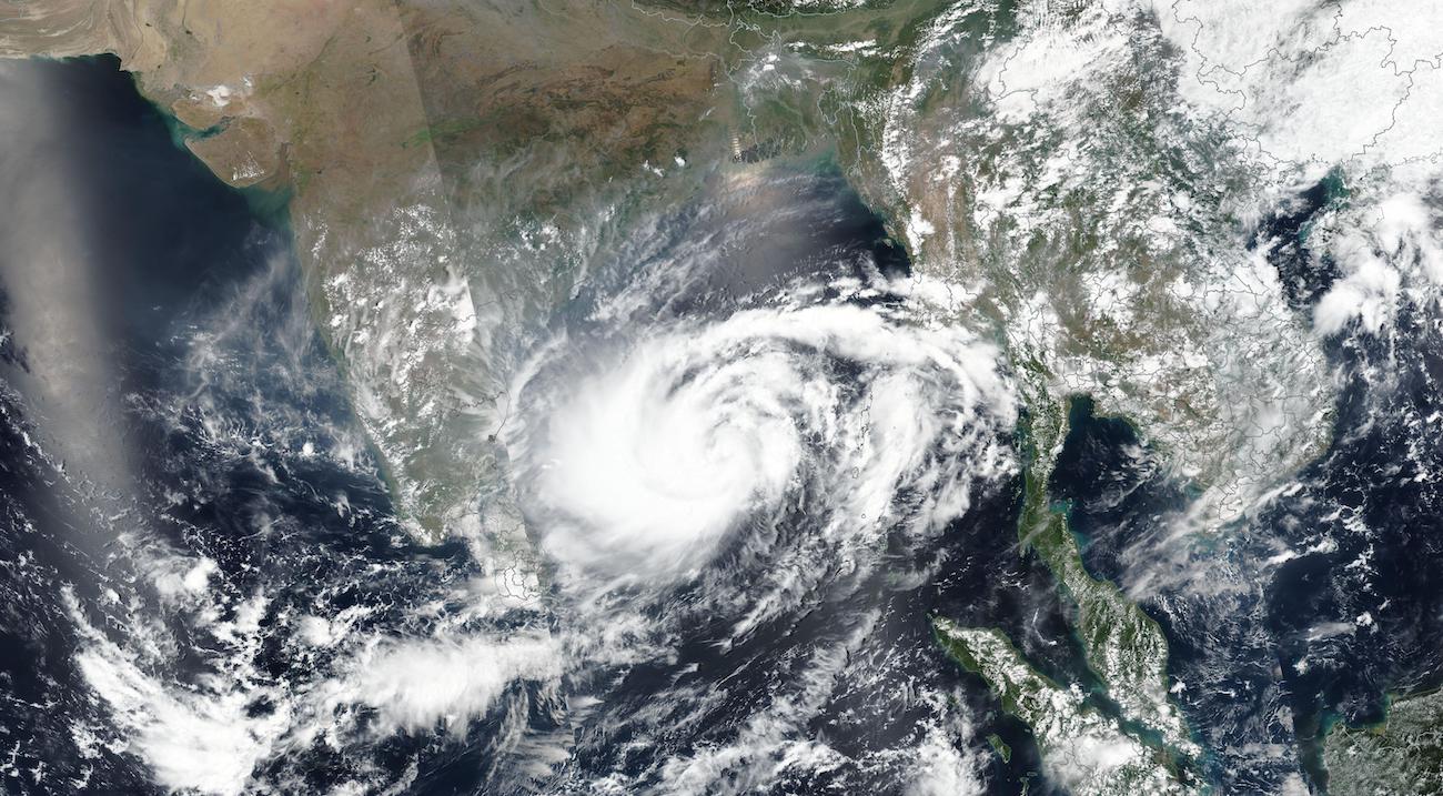
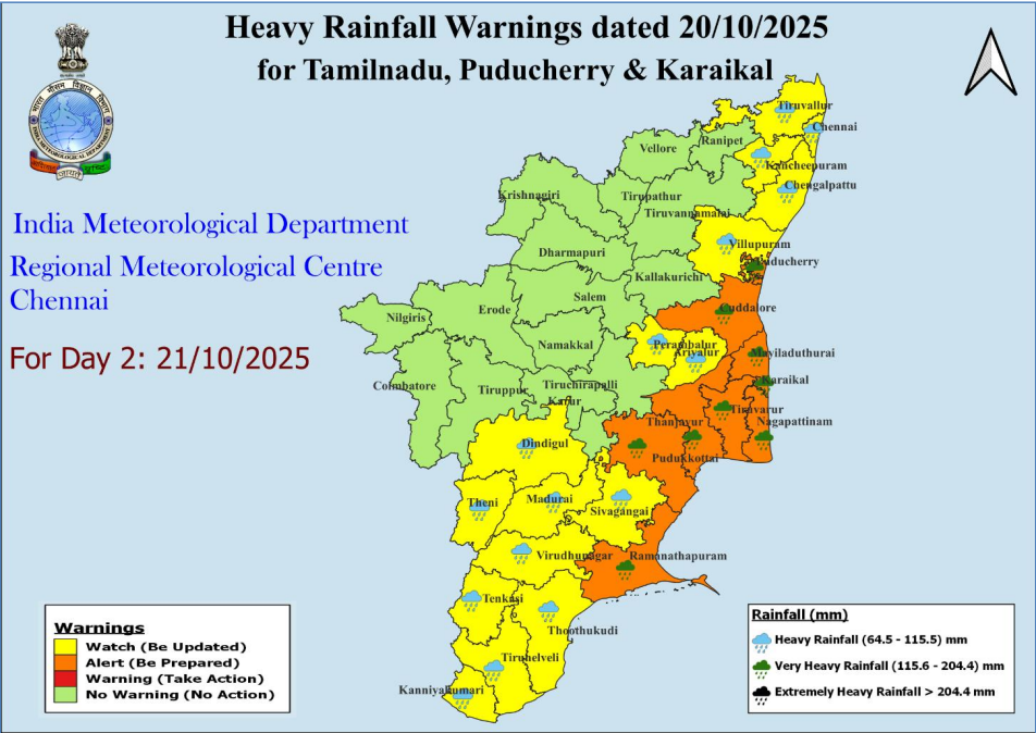
The Indian Meteorological Department (IMD) issues an orange alert for Tamil Nadu as Cyclone Montha is expected to form in the Bay of Bengal. Stay updated on rainfall, wind, and safety tips.
India Meteorological Department (IMD) Issues Orange Alert for Tamil Nadu as New Cyclone “Cyclone Montha” Expected


Summary
The India Meteorological Department (IMD) has issued an orange alert for parts of Tamil Nadu in anticipation of a developing cyclonic system in the Bay of Bengal, tentatively named Cyclone Montha. This alert signals the likelihood of heavy to very heavy rainfall, strong gusty winds, rough seas and potential flooding over the coming days. Coastal and adjoining inland districts of Tamil Nadu need to prepare for impacts and take precautionary measures.
In this article we’ll explain:
- What an orange alert means and why it’s significant
- How Cyclone Montha is forming, its likely path and what the IMD is forecasting
- Which areas of Tamil Nadu are most at risk and the nature of the threats (rain, wind, storm surge)
- What residents, local authorities and visitors should do to prepare
- How to respond during and after the event – safety tips, dos & don’ts
- Some context about cyclones in the Bay of Bengal and Tamil Nadu’s vulnerability
- A brief note on what to watch for next (updates, track changes).
1. What Does an Orange Alert Mean?
Weather‐warning systems by the IMD use colour codes to indicate the level of threat. An orange alert is one of the higher levels of caution, indicating “be prepared” for significant impact. It means conditions are likely to deteriorate, and you should:
- Keep updated via official weather bulletins.
- Review or activate your preparedness measures.
- Anticipate possible disruptions (rain, wind, flooding, travel issues).
For example, recent IMD advisories for Tamil Nadu stated that heavy to very heavy rainfall (7-20 cm or more in 24 hours) is likely in many coastal and adjoining districts. (The Indian Express)
Also, prior orange alerts in the state warned of heavy rainfall causing water-logging, traffic issues, and disruption of daily life. (NativePlanet)
Hence, the orange alert for Cyclone Montha is a clear signal: significant weather event incoming, take it seriously.
2. Cyclone Montha – Formation, Forecast & Path
Formation & Naming
A low-pressure area has developed over the southeast Bay of Bengal and is showing signs of intensification. This system is expected to strengthen into a depression, then into a deep depression and possibly a cyclonic storm, which may be named Montha. (The Times of India)
The name Montha has been proposed (by Thailand), meaning “fragrant flower” or “beautiful flower”. (The Times of India)
Forecasted Timeline & Strength
According to IMD reports:
- Rainfall and thunderstorms likely begin over Tamil Nadu’s coastal districts from 25 October onwards. (The Times of India)
- By 27 October, the system could intensify into a cyclonic storm, with wind speeds of 65-74 km/h expected. (The Times of India)
- Peak rainfall appears forecast for districts like Chennai, Chengalpattu, Vellore around 27 October. (The Times of India)
Likely Path
While exact track remains subject to change, current indicators suggest:
- The system may drift north-northwestwards away from Tamil Nadu mainland, possibly towards Andhra Pradesh. A weather blogger cautions Chennai may “miss the heaviest rains” if the system shifts further away. (The Times of India)
- Nonetheless, even if the main centre shifts, the outer rain bands and wind effects can significantly impact Tamil Nadu’s coast and adjacent inland areas.
Why Bay of Bengal Cyclones Matter for Tamil Nadu
The Bay of Bengal is a known breeding ground for tropical systems especially during the retreating monsoon and Northeast monsoon transition (October-December). Wind shear, warm sea surface temperature, and moisture converge to facilitate storms. Tamil Nadu’s east coast is frequently in the path (directly or through peripheral effects).
Hence, even a system that does not make direct landfall can trigger heavy rainfall, flooding, and local hazards.
3. Which Areas in Tamil Nadu are Most At Risk & The Nature of the Threats
At-risk Districts & Coastal Zones
The IMD bulletin identifies the following districts with heavy to very heavy rainfall likelihood:
- Coastal and adjacent: Chennai, Tiruvallur, Kancheepuram, Ranipet, Tiruvannamalai, Kallakurichi, Ariyalur, Perambalur, Thanjavur, Tiruvarur, Nagapattinam, Karaikal (UT) etc. (The Indian Express)
- Inland & adjoining: Vellore, Chengalpattu, etc.
- Specific warnings also list Cuddalore, Villupuram, Chengalpattu, Puducherry from 25 October onwards. (The Times of India)
Nature of the Hazards
The threats during such a cyclonic scenario are multiple:
| Hazard | What it means | Potential impact |
|---|---|---|
| Heavy rainfall | Rainfall totals of 12–20 cm (or more) in 24 hours expected in some zones. (The Times of India) | Flooding; water-logging; urban drainage overwhelmed. |
| Gusty winds / squalls | Winds reaching > 60 km/h possible as cyclone strengthens. | Uprooted trees, structural damage, power outages. |
| Storm surge / high seas | Coastal waters may rise; waves rough. | Coastal flooding, beach erosion, hazard for fishermen. |
| Inland flooding / runoff | Rain falling on hills or elevated terrain drains to plains. | Landslides in hilly zones, inundation in low-lying areas. |
| Transport & infrastructure disruption | Roads, rail, flights may face delays or closures. | Commuter disruption, economic impact. |
Why Even Peripheral Impacts Matter
Even if the cyclone’s centre stays offshore or moves away, the fringe or outer rain bands can still bring intense rainfall to the coast and adjoining inland zones. As noted by IMD and weather observers, “If the system moves further away … Chennai will only see moderate spells.” (The Times of India)
Thus, the risk cannot be dismissed simply because landfall is uncertain.
4. Preparation & Readiness – What Should Residents, Local Authorities and Visitors Do?
For Residents (Households)
- Stay updated: Monitor official IMD bulletins (via website, apps, TV/radio).
- Emergency kit: Keep torch, batteries, first-aid kit, essential medications, bottled water, non-perishable food, blankets.
- Secure your home: Tie down loose objects, close tsunami gates / drainage valves if applicable, clear out gutters & roof drains.
- Plan for power/communication: Charge phones, keep power banks, know alternative contact methods.
- Avoid risky zones: If you live in low-lying, flood-prone or coastal areas, prepare for relocation if advised; stay away from beaches, sea walls when storm is active.
- Travel & transit caution: Avoid unnecessary travel during heavy rain/wind; anticipate delays.
- Check on neighbours: Especially elderly, disabled or vulnerable neighbours – ensure they are aware and prepared.
For Local Authorities & Disaster Management
- Trigger early-warning systems and public alerts.
- Pre-position rescue & relief teams (State Disaster Response Force, local volunteers).
- Open and staff evacuation centres in flood-prone zones.
- Ensure drainage systems are cleared ahead of heavy rainfall.
- Coordinate with police, transport, health services to plan for contingencies (power outages, road blockages, landslides).
- Issue advisories for fishing community: Stay ashore, avoid venturing into sea.
For Visitors / Tourists
- If you’re visiting coastal or inland Tamil Nadu during this period, stay flexible with plans.
- Avoid beach resorts during storm warnings; check cancellation policies.
- Carry local emergency contacts and know the nearest shelter or safe indoor location.
- Avoid venturing into waterlogged or flooded streets; prefer higher ground if rainfall intensifies.
5. Safety Tips – During & After the Event
During the Cyclone / Rain-Wind Event
- Stay indoors as much as possible; avoid windows during high winds.
- Do not walk or drive through water-logged roads – “Turn around, don’t drown.”
- Keep away from sea, coastal embankments and beach promenades – waves may be large and unpredictable.
- Avoid standing under trees or near electric poles; risk of falling branches / wires.
- If power goes off, switch off major appliances; unplug sensitive electronics.
- Stay tuned to updates via radio/TV/phone; follow instructions from authorities.
After the Event
- Wait for official “all-clear” before venturing outside.
- Be cautious when returning to outdoor areas – watch for fallen wires, water-logging, damaged roads.
- Avoid drinking flood-contaminated water; boil or use safe drinking water.
- Take photos of damage for insurance claims.
- Check neighbours and vulnerable persons; assist if possible.
- Monitor for any secondary hazards (mosquito breeding from stagnant water, landslides if in hilly zones).
6. Context: Cyclones, Bay of Bengal & Tamil Nadu’s Vulnerability
Cyclone Activity in the Bay of Bengal
The Bay of Bengal is home to some of the world’s most intense tropical cyclones, owing to warm sea-surface temperatures, high humidity and the shape of the northern Indian Ocean which funnels storms towards land. Over the years, storms like Cyclone Amphan (2020), Cyclone Fani (2019) made headlines. (Press Information Bureau)
Tamil Nadu’s Exposure
Tamil Nadu’s east coast – including the Coromandel region – frequently faces the brunt of these systems, either via direct landfall or through heavy rains and winds associated with peripheral circulation. Factors that increase vulnerability include:
- Dense coastal population and built-infrastructure.
- Low-lying coastal plains prone to flooding, urban drainage challenges (especially in cities like Chennai).
- Hilly regions (Nilgiris, etc) where heavy rain can lead to landslides.
- Sea-shore tourism and fishing communities with livelihoods tied to sea-conditions.
Improvement in Forecasting & Response
Thanks to advances by IMD in radar network, satellite monitoring, modelling and early-warning systems, cyclone-related fatalities in India have markedly reduced over the past decades. (Press Information Bureau)
Nevertheless, the risk remains high, especially in densely populated coastal zones with complex infrastructure. Hence early preparedness and community awareness are key.
7. What to Watch Next – Follow-Up & Key Indicators
As Cyclone Montha evolves, keep an eye on:
- Track changes: If the system moves closer to Tamil Nadu’s coast, possible upgrade of alert levels (red/yellow) and evacuation orders.
- Rainfall estimates and actual accumulation: If 12-20 cm+ rainfall is expected in 24 hours, risk of widespread water-logging increases. (The Times of India)
- Wind speed forecasts: If winds exceed 60 km/h, expect more structural/wind damage.
- Sea state: For fishermen and coastal communities – high waves, storm surge warnings.
- Local advisories: District-wise warnings by IMD’s Chennai Regional Centre, district authorities.
- Post-event response: How quickly drainage is cleared, power restored, relief operations begin.
Conclusion
With the IMD issuing an orange alert for Tamil Nadu in anticipation of Cyclone Montha, now is the time for communities, authorities and individuals to be alert, prepared and vigilant. While the exact track and landfall remain uncertain, the potential for heavy rain, strong winds, flooding and coastal hazards is real. The east coast of Tamil Nadu has faced such challenges in past years – and the difference often lies in how promptly the warnings are acted upon.
If you live in or are visiting Tamil Nadu, please:
- Take the alert seriously.
- Make necessary preparations now (don’t wait until the rain starts).
- Stay away from risky zones, especially coastal and flooded areas.
- Follow instructions from local authorities and IMD.
By staying prepared, you help reduce the risk to life, property and community welfare.


0 Comments